


parc balzac

bubuserge
User
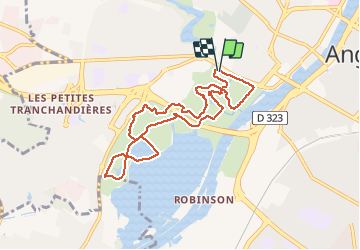

Length
8.5 km

Max alt
27 m

Uphill gradient
61 m
Km-Effort
9.3 km

Min alt
8 m

Downhill gradient
62 m
Boucle
Yes
Creation date :
2019-05-06 23:59:49.692
Updated on :
2020-05-16 14:30:09.22
2h02
Difficulty : Very easy

FREE GPS app for hiking
 SityTrail
IGN / Geographical institutes
SityTrail Plus
The world is yours!
About
Trail Other activity of 8.5 km to be discovered at Pays de la Loire, Maine-et-Loire, Angers. This trail is proposed by bubuserge.
Positioning
Country:
France
Region :
Pays de la Loire
Department/Province :
Maine-et-Loire
Municipality :
Angers
Location:
Unknown
Start:(Dec)
Start:(UTM)
682641 ; 5260454 (30T) N.
Comments