Trail Walking Engolasters - And vall riu madriu-estany de l'illa-grau roig - Photo

And vall riu madriu-estany de l'illa-grau roig

 phidge
phidge

User

© OpenStreetMap contributors
Length
Length
17.5 km
Max alt
Max alt
2849 m
Uphill gradient
Uphill gradient
1604 m
Km-Effort
Km-Effort  
35 km
Min alt
Min alt
1245 m
Downhill gradient
Downhill gradient
554 m
Boucle
Boucle
No
Creation date :
2019-01-19 21:16:46.756
Updated on :
2019-01-19 21:16:46.778

(0 Reviews)

Walking
Walking
--
Difficulty : Very difficult

Scan this QR Code to open this trail in the SityTrail application

FREE GPS app for hiking

Logo SityTrail SityTrail

IGN / Geographical institutes

Download SityTrail from the App Store Download SityTrail from Google Play

Logo SityTrail SityTrail World

The world is yours!

Download SityTrail from the App Store Download SityTrail from Google Play Download SityTrail on Huawei AppGallery

About

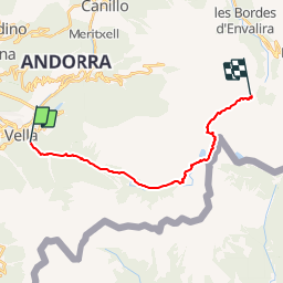
Trail Walking of 17.5 km to be discovered at Andorra. This trail is proposed by phidge.

Description

Longueur: 18,01 kilomètres
Altitude min: 1 238 mètres, max: 2 863 mètres
Dénivelé cum. montée: 1 730 mètres, descente: 754 mètres
Degré de difficulté: skill Facile
Durée:   un jour  une heure 10 minutes

Deixem un cotxe a l'estacio d'esqui grau roig i anem amb el altre a Escaldes per començar la excursio. Anirem per la vall del riu Madriu, de gran bellesa. Farem nit al refugi de L'illa, lliure i al costat d'un bonic llac. Al dia seguent assolirem el pic dels pessons i devallarem fins on tenim el cotxe, a Grau Roig. Una magnifica travessia. Si voleu acompanyar-nos a les nostres sortides us podeu informar a:

http://www.falconssabadell.org/muntanya/

Allí podeu anar al forum de muntanya i al forum de la fecc, on estan les excursions previstes. Si ens voleu acompanyar hi esteu invitats. Sols volem ganes de caminar i bon companyerisme.

Elevation profile

Positioning

Country:
Andorra
Region :
Escaldes-Engordany
Department/Province :
Escaldes-Engordany
Municipality :
Engolasters
Location:
Unknown
Start:(UTM)
380967 ; 4706756 (31T) N.

Trails nearby

Trail Walking  - Andorre-lac-d-Angolaster-11-juil-2017 - Photo
Walking
GUIDE
Nordic33

Walking

Medium
, , , Andorra
7.8 km | 10.1 km-effort
2h 18min
Yes
Trail Walking  - Andorre TSM groupe 2 mardi 10 septembre matin - Photo
Walking
zanogueb

Walking

Easy
, , , Andorra
4 km | 5.5 km-effort
1h 46min
Yes
Trail Walking  - chemin de la fontanas et bailmadriu - Photo
Walking
JEANJOSY

Walking

Medium
, , , Andorra
14.2 km | 23 km-effort
5h 38min
Yes
Trail Other activity  - Engolasters Ramió - Photo
Other activity
elviking

Other activity

Medium
, , , Andorra
7.2 km | 11.2 km-effort
2h 50min
No
Trail Walking  - 49 - Itinéraire de Perafita - Photo
Walking
hbonnard

Walking

Difficult
, , , Andorra
9.1 km | 22 km-effort
4h 12min
No
Trail Walking  - 54 - Lac Blau - Photo
Walking
hbonnard

Walking

Difficult
, , , Andorra
14.9 km | 31 km-effort
6h 17min
No
Trail Motor  - a-spanje-bergen-andorra-en-spanje - Photo
Motor
gpstracks

Motor

Very easy
, , , Andorra
219 km | 497 km-effort
Unknown
Yes
Trail Walking  - Itinerari de la Vall del Madriu (estany de la bova) - Photo
Walking
phidge

Walking

Very easy
, , , Andorra
10.1 km | 22 km-effort
Unknown
No
Trail Walking  - 52 Itinerari fontverd - Photo
Walking
phidge

Walking

Very easy
, , , Andorra
8.1 km | 13.2 km-effort
Unknown
No


Close
My subscriptions