


LE CHEMIN DE LARRAZET

Marco44
User
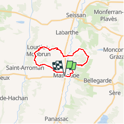

Length
19.5 km

Max alt
301 m

Uphill gradient
318 m
Km-Effort
24 km

Min alt
190 m

Downhill gradient
320 m
Boucle
Yes
Creation date :
2019-05-07 00:19:23.311
Updated on :
2019-05-07 00:19:23.311
--
Difficulty : Unknown

FREE GPS app for hiking
 SityTrail
IGN / Geographical institutes
SityTrail Plus
The world is yours!
About
Trail Other activity of 19.5 km to be discovered at Occitania, Gers, Masseube. This trail is proposed by Marco44.
Description
Une randonnée longue distance au départ de Masseube.


Positioning
Country:
France
Region :
Occitania
Department/Province :
Gers
Municipality :
Masseube
Location:
Unknown
Start:(Dec)
Start:(UTM)
303896 ; 4811405 (31T) N.
Comments