


Beaumont la ronce circuit bleu.

dporcher
User
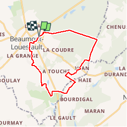

Length
13.1 km

Max alt
160 m

Uphill gradient
162 m
Km-Effort
15.3 km

Min alt
97 m

Downhill gradient
162 m
Boucle
Yes
Creation date :
2019-05-07 00:23:11.266
Updated on :
2019-05-07 00:23:11.266
2h40
Difficulty : Easy

FREE GPS app for hiking
 SityTrail
IGN / Geographical institutes
SityTrail Plus
The world is yours!
About
Trail Walking of 13.1 km to be discovered at Centre-Loire Valley, Indre-et-Loire, Beaumont-Louestault. This trail is proposed by dporcher.
Positioning
Country:
France
Region :
Centre-Loire Valley
Department/Province :
Indre-et-Loire
Municipality :
Beaumont-Louestault
Location:
Beaumont-la-Ronce
Start:(Dec)
Start:(UTM)
325362 ; 5271267 (31T) N.
Comments