


haute clarèe

longa
User

Length
24 km

Max alt
1703 m

Uphill gradient
452 m
Km-Effort
30 km

Min alt
1405 m

Downhill gradient
454 m
Boucle
Yes
Creation date :
2014-12-10 00:00:00.0
Updated on :
2014-12-10 00:00:00.0
1h29
Difficulty : Medium

FREE GPS app for hiking
 SityTrail
IGN / Geographical institutes
SityTrail Plus
The world is yours!
About
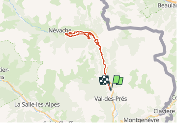
Trail Winter sports of 24 km to be discovered at Provence-Alpes-Côte d'Azur, Hautes-Alpes, Val-des-Prés. This trail is proposed by longa.
Positioning
Country:
France
Region :
Provence-Alpes-Côte d'Azur
Department/Province :
Hautes-Alpes
Municipality :
Val-des-Prés
Location:
Unknown
Start:(Dec)
Start:(UTM)
316710 ; 4980958 (32T) N.
Comments