


Pradelle

ajd26
User
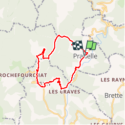

Length
14.5 km

Max alt
1064 m

Uphill gradient
700 m
Km-Effort
24 km

Min alt
502 m

Downhill gradient
703 m
Boucle
Yes
Creation date :
2019-05-19 18:03:03.554
Updated on :
2019-05-19 18:03:03.669
4h41
Difficulty : Easy

FREE GPS app for hiking
 SityTrail
IGN / Geographical institutes
SityTrail Plus
The world is yours!
About
Trail Walking of 14.5 km to be discovered at Auvergne-Rhône-Alpes, Drôme, Pradelle. This trail is proposed by ajd26.
Description
Boucle autour de Pradelle par les cols Trepalon, Caillaud et chapelle notre Dame. Passe à proximité d'un élevage d'alpagas
Positioning
Country:
France
Region :
Auvergne-Rhône-Alpes
Department/Province :
Drôme
Municipality :
Pradelle
Location:
Unknown
Start:(Dec)
Start:(UTM)
681758 ; 4941933 (31T) N.
Comments