


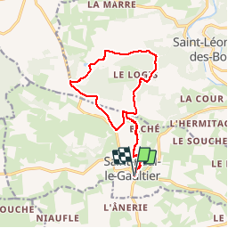
St Paul le Gauthier - Chemasson (le bois de) 13.90km

Marie-Claire-mcp
User


3h34
Difficulty : Medium

FREE GPS app for hiking
 SityTrail
IGN / Geographical institutes
SityTrail Plus
The world is yours!
About
Trail Walking of 13.9 km to be discovered at Pays de la Loire, Sarthe, Saint-Paul-le-Gaultier. This trail is proposed by Marie-Claire-mcp.
Description
Départ des étangs de St Paul le Gaultier, puis remontée la rue du Bief et tourner à l'église. Monter vers le Biché, puis la croix rousse, la plardière puis les chapronnières et contourner le bois de Chemasson par les maisonnettes et Villeneuve, redescendre par la Talbotière et reprendre le même chemin qu'à l'aller.
Photos
 13.90km - Photo 1")
 13.90km - Photo 2")
 13.90km - Photo 3")
 13.90km - Photo 4")
 13.90km - Photo 5")
 13.90km - Photo 6")
 13.90km - Photo 7")
 13.90km - Photo 8")
 13.90km - Photo 9")
 13.90km - Photo 10")
 13.90km - Photo 11")
 13.90km - Photo 12")
 13.90km - Photo 13")
 13.90km - Photo 14")
 13.90km - Photo 15")
 13.90km - Photo 16")
 13.90km - Photo 17")
 13.90km - Photo 18")
 13.90km - Photo 19")
 13.90km - Photo 20")
 13.90km - Photo 21")
 13.90km - Photo 22")
 13.90km - Photo 23")
 13.90km - Photo 24")
 13.90km - Photo 25")
 13.90km - Photo 26")
 13.90km - Photo 27")
27 photos in total. Please click on a photo to see them all in the gallery.
Positioning
Comments