


Le Rouret - Trepaloup

pb07
User
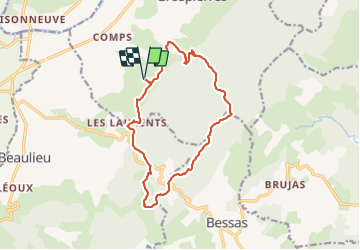

Length
14.6 km

Max alt
460 m

Uphill gradient
473 m
Km-Effort
21 km

Min alt
142 m

Downhill gradient
473 m
Boucle
Yes
Creation date :
2019-04-28 20:12:24.893
Updated on :
2019-04-28 20:12:24.893
5h10
Difficulty : Unknown

FREE GPS app for hiking
 SityTrail
IGN / Geographical institutes
SityTrail Plus
The world is yours!
About
Trail Walking of 14.6 km to be discovered at Auvergne-Rhône-Alpes, Ardèche, Grospierres. This trail is proposed by pb07.
Positioning
Country:
France
Region :
Auvergne-Rhône-Alpes
Department/Province :
Ardèche
Municipality :
Grospierres
Location:
Unknown
Start:(Dec)
Start:(UTM)
601418 ; 4914824 (31T) N.
Comments