


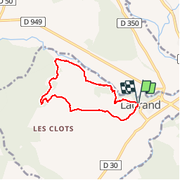
circuit de lagrand

fitz2014
User

Length
6.2 km

Max alt
761 m

Uphill gradient
171 m
Km-Effort
8.5 km

Min alt
614 m

Downhill gradient
177 m
Boucle
Yes
Creation date :
2019-05-07 01:08:57.962
Updated on :
2019-05-07 01:08:57.962
1h53
Difficulty : Easy

FREE GPS app for hiking
 SityTrail
IGN / Geographical institutes
SityTrail Plus
The world is yours!
About
Trail Walking of 6.2 km to be discovered at Provence-Alpes-Côte d'Azur, Hautes-Alpes, Garde-Colombe. This trail is proposed by fitz2014.
Positioning
Country:
France
Region :
Provence-Alpes-Côte d'Azur
Department/Province :
Hautes-Alpes
Municipality :
Garde-Colombe
Location:
Unknown
Start:(Dec)
Start:(UTM)
719667 ; 4913503 (31T) N.
Comments