


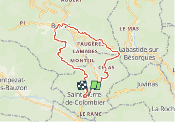
Saint Pierre le Colombier-Burzet

Lustou
User

Length
16.7 km

Max alt
863 m

Uphill gradient
802 m
Km-Effort
27 km

Min alt
401 m

Downhill gradient
802 m
Boucle
Yes
Creation date :
2019-04-26 19:24:46.473
Updated on :
2019-04-26 19:24:46.473
5h36
Difficulty : Unknown

FREE GPS app for hiking
 SityTrail
IGN / Geographical institutes
SityTrail Plus
The world is yours!
About
Trail Walking of 16.7 km to be discovered at Auvergne-Rhône-Alpes, Ardèche, Saint-Pierre-de-Colombier. This trail is proposed by Lustou.
Positioning
Country:
France
Region :
Auvergne-Rhône-Alpes
Department/Province :
Ardèche
Municipality :
Saint-Pierre-de-Colombier
Location:
Unknown
Start:(Dec)
Start:(UTM)
600190 ; 4950930 (31T) N.
Comments