


Châteauneuf Villevieille

Renefrt
User
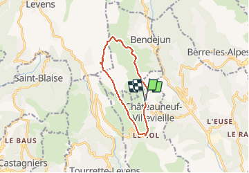

Length
11.3 km

Max alt
885 m

Uphill gradient
558 m
Km-Effort
18.7 km

Min alt
539 m

Downhill gradient
556 m
Boucle
Yes
Creation date :
2019-04-24 11:19:29.843
Updated on :
2019-04-24 11:19:29.843
6h10
Difficulty : Medium

FREE GPS app for hiking
 SityTrail
IGN / Geographical institutes
SityTrail Plus
The world is yours!
About
Trail Other activity of 11.3 km to be discovered at Provence-Alpes-Côte d'Azur, Maritime Alps, Châteauneuf-Villevieille. This trail is proposed by Renefrt.
Description
Suivre le sens
Photos


Positioning
Country:
France
Region :
Provence-Alpes-Côte d'Azur
Department/Province :
Maritime Alps
Municipality :
Châteauneuf-Villevieille
Location:
Unknown
Start:(Dec)
Start:(UTM)
362691 ; 4852508 (32T) N.
Comments