


8666923-Cime de la Cacia en boucle

Renefrt
User
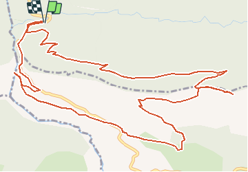

Length
8.9 km

Max alt
1087 m

Uphill gradient
587 m
Km-Effort
16.7 km

Min alt
576 m

Downhill gradient
595 m
Boucle
Yes
Creation date :
2019-04-24 11:19:25.424
Updated on :
2020-08-12 14:32:03.179
--
Difficulty : Medium

FREE GPS app for hiking
 SityTrail
IGN / Geographical institutes
SityTrail Plus
The world is yours!
About
Trail On foot of 8.9 km to be discovered at Provence-Alpes-Côte d'Azur, Maritime Alps, Cuébris. This trail is proposed by Renefrt.
Positioning
Country:
France
Region :
Provence-Alpes-Côte d'Azur
Department/Province :
Maritime Alps
Municipality :
Cuébris
Location:
Unknown
Start:(Dec)
Start:(UTM)
334580 ; 4861334 (32T) N.
Comments