


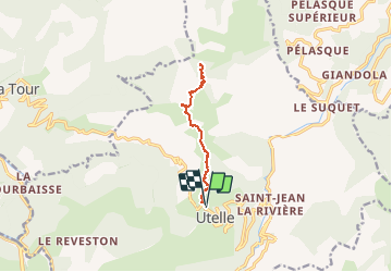
9338333-BREC D UTELLE

Renefrt
User

Length
10.9 km

Max alt
1541 m

Uphill gradient
800 m
Km-Effort
22 km

Min alt
827 m

Downhill gradient
791 m
Boucle
Yes
Creation date :
2019-04-24 11:19:19.795
Updated on :
2020-08-09 17:58:27.345
4h17
Difficulty : Difficult

FREE GPS app for hiking
 SityTrail
IGN / Geographical institutes
SityTrail Plus
The world is yours!
About
Trail Walking of 10.9 km to be discovered at Provence-Alpes-Côte d'Azur, Maritime Alps, Utelle. This trail is proposed by Renefrt.
Positioning
Country:
France
Region :
Provence-Alpes-Côte d'Azur
Department/Province :
Maritime Alps
Municipality :
Utelle
Location:
Unknown
Start:(Dec)
Start:(UTM)
359094 ; 4864424 (32T) N.
Comments