


Levens Nice

Renefrt
User
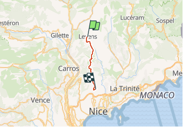

Length
16.4 km

Max alt
755 m

Uphill gradient
581 m
Km-Effort
25 km

Min alt
318 m

Downhill gradient
804 m
Boucle
No
Creation date :
2019-04-24 11:19:07.575
Updated on :
2019-04-24 11:19:07.575
9h07
Difficulty : Medium

FREE GPS app for hiking
 SityTrail
IGN / Geographical institutes
SityTrail Plus
The world is yours!
About
Trail Walking of 16.4 km to be discovered at Provence-Alpes-Côte d'Azur, Maritime Alps, Levens. This trail is proposed by Renefrt.
Photos


Positioning
Country:
France
Region :
Provence-Alpes-Côte d'Azur
Department/Province :
Maritime Alps
Municipality :
Levens
Location:
Unknown
Start:(Dec)
Start:(UTM)
358510 ; 4856280 (32T) N.
Comments