


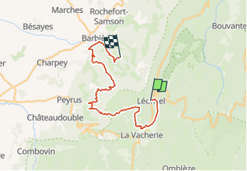
J4 VERCORS LIGNE RETOUR

ophness
User

Length
24 km

Max alt
1123 m

Uphill gradient
813 m
Km-Effort
36 km

Min alt
429 m

Downhill gradient
1188 m
Boucle
No
Creation date :
2019-05-03 16:22:02.988
Updated on :
2019-05-03 16:22:02.988
4h16
Difficulty : Unknown

FREE GPS app for hiking
 SityTrail
IGN / Geographical institutes
SityTrail Plus
The world is yours!
About
Trail Equestrian of 24 km to be discovered at Auvergne-Rhône-Alpes, Drôme, Léoncel. This trail is proposed by ophness.
Positioning
Country:
France
Region :
Auvergne-Rhône-Alpes
Department/Province :
Drôme
Municipality :
Léoncel
Location:
Unknown
Start:(Dec)
Start:(UTM)
673034 ; 4975465 (31T) N.
Comments