


Font joyeuse Mireil 3 Collets Combre

Nathy8913
User
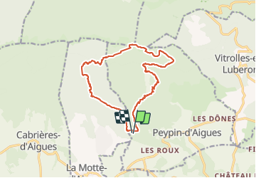

Length
17.7 km

Max alt
971 m

Uphill gradient
687 m
Km-Effort
27 km

Min alt
421 m

Downhill gradient
687 m
Boucle
Yes
Creation date :
2019-05-07 01:50:15.334
Updated on :
2019-05-07 01:50:15.334
5h01
Difficulty : Unknown

FREE GPS app for hiking
 SityTrail
IGN / Geographical institutes
SityTrail Plus
The world is yours!
About
Trail Walking of 17.7 km to be discovered at Provence-Alpes-Côte d'Azur, Vaucluse, Peypin-d'Aigues. This trail is proposed by Nathy8913.
Description
moyen
Positioning
Country:
France
Region :
Provence-Alpes-Côte d'Azur
Department/Province :
Vaucluse
Municipality :
Peypin-d'Aigues
Location:
Unknown
Start:(Dec)
Start:(UTM)
704675 ; 4851374 (31T) N.
Comments