


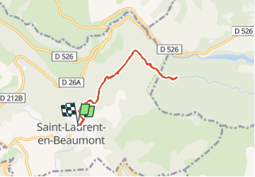
Valbonnais Canal Beaumont StLaurent

Orcal37
User GUIDE

Length
6.8 km

Max alt
977 m

Uphill gradient
132 m
Km-Effort
8.6 km

Min alt
919 m

Downhill gradient
133 m
Boucle
Yes
Creation date :
2019-05-07 01:56:00.968
Updated on :
2021-09-07 15:12:10.601
1h35
Difficulty : Easy

FREE GPS app for hiking
 SityTrail
IGN / Geographical institutes
SityTrail Plus
The world is yours!
About
Trail Walking of 6.8 km to be discovered at Auvergne-Rhône-Alpes, Isère, Saint-Laurent-en-Beaumont. This trail is proposed by Orcal37.
Description
Valbonnais - Canal du Beaumont -St-Laurent
Photos


Positioning
Country:
France
Region :
Auvergne-Rhône-Alpes
Department/Province :
Isère
Municipality :
Saint-Laurent-en-Beaumont
Location:
Unknown
Start:(Dec)
Start:(UTM)
725180 ; 4973494 (31T) N.
Comments