


Tours-2015-04-19

Orcal37
User GUIDE
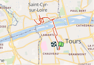

Length
8.1 km

Max alt
95 m

Uphill gradient
155 m
Km-Effort
10.2 km

Min alt
47 m

Downhill gradient
155 m
Boucle
Yes
Creation date :
2019-05-07 01:56:05.156
Updated on :
2021-09-13 17:34:03.395
1h40
Difficulty : Very easy

FREE GPS app for hiking
 SityTrail
IGN / Geographical institutes
SityTrail Plus
The world is yours!
About
Trail Walking of 8.1 km to be discovered at Centre-Loire Valley, Indre-et-Loire, Tours. This trail is proposed by Orcal37.
Description
Tours - St-Cyr - 19-04-2015
Positioning
Country:
France
Region :
Centre-Loire Valley
Department/Province :
Indre-et-Loire
Municipality :
Tours
Location:
Unknown
Start:(Dec)
Start:(UTM)
324796 ; 5250684 (31T) N.
Comments