


Azay-sur-Cher - 2015 08 02 - boucle 10 km

Orcal37
User GUIDE
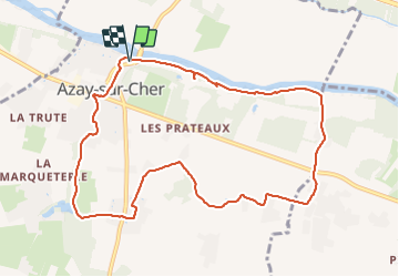

Length
10.3 km

Max alt
96 m

Uphill gradient
111 m
Km-Effort
11.8 km

Min alt
48 m

Downhill gradient
110 m
Boucle
Yes
Creation date :
2019-05-07 01:56:17.46
Updated on :
2021-08-09 14:28:30.141
2h10
Difficulty : Easy

FREE GPS app for hiking
 SityTrail
IGN / Geographical institutes
SityTrail Plus
The world is yours!
About
Trail Walking of 10.3 km to be discovered at Centre-Loire Valley, Indre-et-Loire, Azay-sur-Cher. This trail is proposed by Orcal37.
Description
Azay-sur-Cher - 2015 08 02 - boucle 10 km
Photos


Positioning
Country:
France
Region :
Centre-Loire Valley
Department/Province :
Indre-et-Loire
Municipality :
Azay-sur-Cher
Location:
Unknown
Start:(Dec)
Start:(UTM)
337584 ; 5246423 (31T) N.
Comments