


Lac des Bretonnières - Joué - 2016 02 07

Orcal37
User GUIDE
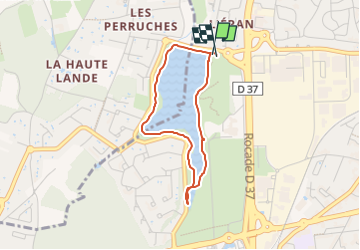

Length
2.9 km

Max alt
83 m

Uphill gradient
27 m
Km-Effort
3.2 km

Min alt
71 m

Downhill gradient
25 m
Boucle
Yes
Creation date :
2019-05-07 01:56:18.385
Updated on :
2022-09-08 15:25:16.795
30m
Difficulty : Very easy

FREE GPS app for hiking
 SityTrail
IGN / Geographical institutes
SityTrail Plus
The world is yours!
About
Trail Walking of 2.9 km to be discovered at Centre-Loire Valley, Indre-et-Loire, Joué-lès-Tours. This trail is proposed by Orcal37.
Description
Lac des Bretonnières - Joué-lès-Tours
Photos

Positioning
Country:
France
Region :
Centre-Loire Valley
Department/Province :
Indre-et-Loire
Municipality :
Joué-lès-Tours
Location:
Unknown
Start:(Dec)
Start:(UTM)
321980 ; 5247507 (31T) N.
Comments