


Luynes - 2016 04 17

Orcal37
User GUIDE
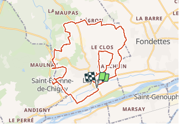

Length
25 km

Max alt
104 m

Uphill gradient
270 m
Km-Effort
28 km

Min alt
40 m

Downhill gradient
270 m
Boucle
Yes
Creation date :
2019-05-07 01:56:48.092
Updated on :
2020-09-05 16:52:55.291
5h05
Difficulty : Medium

FREE GPS app for hiking
 SityTrail
IGN / Geographical institutes
SityTrail Plus
The world is yours!
About
Trail Walking of 25 km to be discovered at Centre-Loire Valley, Indre-et-Loire, Luynes. This trail is proposed by Orcal37.
Description
Sentiers aqueduc et moulins, puis château aqueduc prieuré
Photos

Positioning
Country:
France
Region :
Centre-Loire Valley
Department/Province :
Indre-et-Loire
Municipality :
Luynes
Location:
Unknown
Start:(Dec)
Start:(UTM)
315643 ; 5250476 (31T) N.
Comments