


Pernay - 18.4km - 4h40 - 2016 05 01

Orcal37
User GUIDE
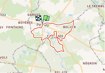

Length
18.4 km

Max alt
112 m

Uphill gradient
233 m
Km-Effort
22 km

Min alt
64 m

Downhill gradient
233 m
Boucle
Yes
Creation date :
2019-05-07 01:56:54.919
Updated on :
2021-08-24 15:57:28.053
4h40
Difficulty : Easy

FREE GPS app for hiking
 SityTrail
IGN / Geographical institutes
SityTrail Plus
The world is yours!
About
Trail Walking of 18.4 km to be discovered at Centre-Loire Valley, Indre-et-Loire, Pernay. This trail is proposed by Orcal37.
Description
Pernay - 18.4km - 4h40 - 2016 05 01
Photos


Positioning
Country:
France
Region :
Centre-Loire Valley
Department/Province :
Indre-et-Loire
Municipality :
Pernay
Location:
Unknown
Start:(Dec)
Start:(UTM)
311442 ; 5257513 (31T) N.
Comments