


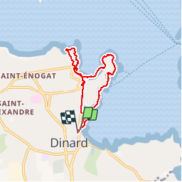
Dinard - 6km 120m 2h00 - 2017 06 20

Orcal37
User GUIDE

Length
6 km

Max alt
31 m

Uphill gradient
99 m
Km-Effort
7.3 km

Min alt
0 m

Downhill gradient
95 m
Boucle
Yes
Creation date :
2019-05-07 01:57:30.797
Updated on :
2019-08-12 18:46:55.375
2h00
Difficulty : Very easy

FREE GPS app for hiking
 SityTrail
IGN / Geographical institutes
SityTrail Plus
The world is yours!
About
Trail Walking of 6 km to be discovered at Brittany, Ille-et-Vilaine, Dinard. This trail is proposed by Orcal37.
Description
Dinard - 6km 120m 2h00 - 2017 06 20
Photos


Positioning
Country:
France
Region :
Brittany
Department/Province :
Ille-et-Vilaine
Municipality :
Dinard
Location:
Unknown
Start:(Dec)
Start:(UTM)
569594 ; 5386452 (30U) N.
Comments