


col

Berpav
User
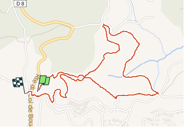

Length
3.4 km

Max alt
232 m

Uphill gradient
148 m
Km-Effort
5.4 km

Min alt
148 m

Downhill gradient
157 m
Boucle
Yes
Creation date :
2019-05-07 02:05:21.851
Updated on :
2021-04-30 13:14:44.776
2h15
Difficulty : Unknown

FREE GPS app for hiking
 SityTrail
IGN / Geographical institutes
SityTrail Plus
The world is yours!
About
Trail Walking of 3.4 km to be discovered at Provence-Alpes-Côte d'Azur, Var, Roquebrune-sur-Argens. This trail is proposed by Berpav.
Description
marche
Photos

Positioning
Country:
France
Region :
Provence-Alpes-Côte d'Azur
Department/Province :
Var
Municipality :
Roquebrune-sur-Argens
Location:
Unknown
Start:(Dec)
Start:(UTM)
311525 ; 4803813 (32T) N.
Comments