


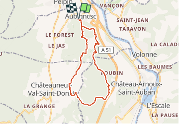
AUBIGNOSC Chateau neuf Val Saint Donnât

RobinMicheline
User GUIDE

Length
15.7 km

Max alt
668 m

Uphill gradient
469 m
Km-Effort
22 km

Min alt
470 m

Downhill gradient
468 m
Boucle
Yes
Creation date :
2019-05-16 07:39:17.041
Updated on :
2019-12-22 17:11:41.187
4h37
Difficulty : Medium

FREE GPS app for hiking
 SityTrail
IGN / Geographical institutes
SityTrail Plus
The world is yours!
About
Trail Walking of 15.7 km to be discovered at Provence-Alpes-Côte d'Azur, Alpes-de-Haute-Provence, Aubignosc. This trail is proposed by RobinMicheline.
Description
CHATEAU ARNOUX
Positioning
Country:
France
Region :
Provence-Alpes-Côte d'Azur
Department/Province :
Alpes-de-Haute-Provence
Municipality :
Aubignosc
Location:
Unknown
Start:(Dec)
Start:(UTM)
737460 ; 4890420 (31T) N.
Comments