


29/03/2019

microb
User
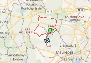

Length
11.5 km

Max alt
177 m

Uphill gradient
198 m
Km-Effort
13.9 km

Min alt
76 m

Downhill gradient
150 m
Boucle
No
Creation date :
2019-05-07 02:13:11.918
Updated on :
2019-05-07 02:13:11.918
2h34
Difficulty : Medium

FREE GPS app for hiking
 SityTrail
IGN / Geographical institutes
SityTrail Plus
The world is yours!
About
Trail Nordic walking of 11.5 km to be discovered at Ile-de-France, Yvelines, Maurepas. This trail is proposed by microb.
Description
Plaine de Jouars (Denis)
Positioning
Country:
France
Region :
Ile-de-France
Department/Province :
Yvelines
Municipality :
Maurepas
Location:
Unknown
Start:(Dec)
Start:(UTM)
420751 ; 5403122 (31U) N.
Comments