


Panoramique Sancy

choubaka77
User
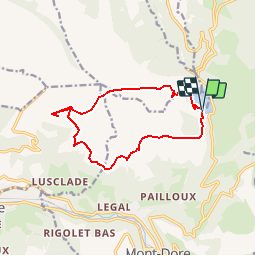

Length
12.3 km

Max alt
1474 m

Uphill gradient
447 m
Km-Effort
18.3 km

Min alt
1243 m

Downhill gradient
449 m
Boucle
Yes
Creation date :
2019-05-07 02:53:11.272
Updated on :
2019-05-07 02:53:11.272
3h48
Difficulty : Easy

FREE GPS app for hiking
 SityTrail
IGN / Geographical institutes
SityTrail Plus
The world is yours!
About
Trail Walking of 12.3 km to be discovered at Auvergne-Rhône-Alpes, Puy-de-Dôme, Mont-Dore. This trail is proposed by choubaka77.
Positioning
Country:
France
Region :
Auvergne-Rhône-Alpes
Department/Province :
Puy-de-Dôme
Municipality :
Mont-Dore
Location:
Unknown
Start:(Dec)
Start:(UTM)
486135 ; 5051000 (31T) N.
Comments