


Grèce - Tinos

phil88
User

Length
10.3 km

Max alt
166 m

Uphill gradient
336 m
Km-Effort
14.9 km

Min alt
1 m

Downhill gradient
343 m
Boucle
Yes
Creation date :
2019-05-07 03:02:19.887
Updated on :
2019-05-07 03:02:19.887
7h47
Difficulty : Medium

FREE GPS app for hiking
 SityTrail
IGN / Geographical institutes
SityTrail Plus
The world is yours!
About
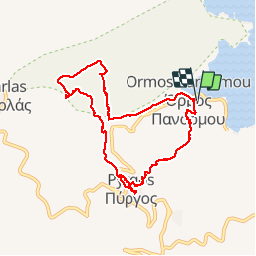
Trail Walking of 10.3 km to be discovered at Aegean, Tinos Regional Unit. This trail is proposed by phil88.
Description
Panormos - Pyrgos - Panormos
Photos


Positioning
Country:
Greece
Region :
Aegean
Department/Province :
Tinos Regional Unit
Municipality :
Όρμος Πανόρμου
Location:
Unknown
Start:(Dec)
Start:(UTM)
328213 ; 4168902 (35S) N.
Comments