


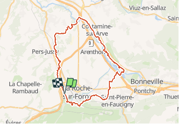
VTT (74) Le Bord de l'Arve depuis Eteaux

HG74250
User

Length
33 km

Max alt
632 m

Uphill gradient
386 m
Km-Effort
39 km

Min alt
427 m

Downhill gradient
389 m
Boucle
Yes
Creation date :
2019-05-02 19:07:37.728
Updated on :
2020-01-04 17:56:15.484
3h00
Difficulty : Easy

FREE GPS app for hiking
 SityTrail
IGN / Geographical institutes
SityTrail Plus
The world is yours!
About
Trail Mountain bike of 33 km to be discovered at Auvergne-Rhône-Alpes, Upper Savoy, Etaux. This trail is proposed by HG74250.
Positioning
Country:
France
Region :
Auvergne-Rhône-Alpes
Department/Province :
Upper Savoy
Municipality :
Etaux
Location:
Unknown
Start:(Dec)
Start:(UTM)
290832 ; 5104898 (32T) N.
Comments