


marlenheim

VacheKiri67
User
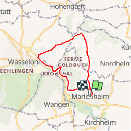

Length
11 km

Max alt
368 m

Uphill gradient
349 m
Km-Effort
15.7 km

Min alt
191 m

Downhill gradient
349 m
Boucle
Yes
Creation date :
2019-05-07 03:18:57.922
Updated on :
2019-05-31 18:49:26.316
3h17
Difficulty : Medium

FREE GPS app for hiking
 SityTrail
IGN / Geographical institutes
SityTrail Plus
The world is yours!
About
Trail Walking of 11 km to be discovered at Grand Est, Bas-Rhin, Marlenheim. This trail is proposed by VacheKiri67.
Description
D'après https://www.visorando.com/randonnee-circuit-sur-les-hauteurs-de-marlenheim-w/
Faite le 01/05/2019.
Photos


Positioning
Country:
France
Region :
Grand Est
Department/Province :
Bas-Rhin
Municipality :
Marlenheim
Location:
Unknown
Start:(Dec)
Start:(UTM)
388721 ; 5386503 (32U) N.
Comments