


SityTrail - Orgon

Berpav
User
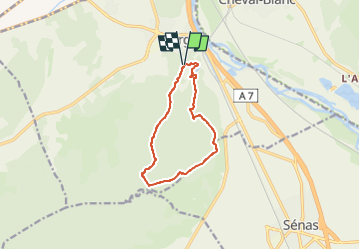

Length
10.5 km

Max alt
273 m

Uphill gradient
202 m
Km-Effort
13.2 km

Min alt
88 m

Downhill gradient
203 m
Boucle
Yes
Creation date :
2019-05-07 03:19:07.112
Updated on :
2024-04-11 15:53:38.494
--
Difficulty : Unknown

FREE GPS app for hiking
 SityTrail
IGN / Geographical institutes
SityTrail Plus
The world is yours!
About
Trail Other activity of 10.5 km to be discovered at Provence-Alpes-Côte d'Azur, Bouches-du-Rhône, Orgon. This trail is proposed by Berpav.
Positioning
Country:
France
Region :
Provence-Alpes-Côte d'Azur
Department/Province :
Bouches-du-Rhône
Municipality :
Orgon
Location:
Unknown
Start:(Dec)
Start:(UTM)
664020 ; 4849953 (31T) N.
Comments
super😀😀