


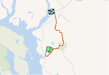
traversée des monts Groulx

lscheven
User

Length
46 km

Max alt
1102 m

Uphill gradient
1909 m
Km-Effort
72 km

Min alt
412 m

Downhill gradient
1904 m
Boucle
No
Creation date :
2014-12-11 00:00:00.0
Updated on :
2014-12-11 00:00:00.0
--
Difficulty : Medium

FREE GPS app for hiking
 SityTrail
IGN / Geographical institutes
SityTrail World
The world is yours!
About
Trail Walking of 46 km to be discovered at Quebec, Manicouagan, Rivière-aux-Outardes. This trail is proposed by lscheven.
Points of interest


Positioning
Country:
Canada
Region :
Quebec
Department/Province :
Manicouagan
Municipality :
Rivière-aux-Outardes
Location:
Unknown
Start:(Dec)
Start:(UTM)
554940 ; 5702121 (19U) N.
Comments
Trails nearby