


Nouveau guide

leclere
User
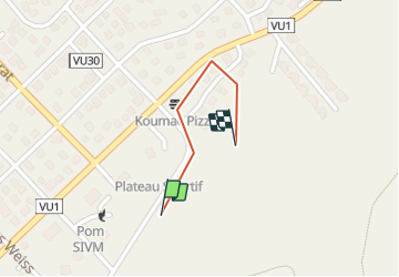

Length
552 m

Max alt
36 m

Uphill gradient
10 m
Km-Effort
668 m

Min alt
24 m

Downhill gradient
5 m
Boucle
No
Creation date :
2016-03-09 00:00:00.0
Updated on :
2016-03-09 00:00:00.0
--
Difficulty : Unknown

FREE GPS app for hiking
 SityTrail
IGN / Geographical institutes
SityTrail Plus
The world is yours!
About
Trail Other activity of 552 m to be discovered at Unknown, North Province, Koumac. This trail is proposed by leclere.


Positioning
Country:
France
Region :
Unknown
Department/Province :
North Province
Municipality :
Koumac
Location:
Unknown
Start:(Dec)
Start:(UTM)
426059 ; 7726946 (58K) S.
Comments