


2011-11-27 18h18m34

ludo39
User
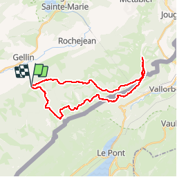

Length
29 km

Max alt
1451 m

Uphill gradient
939 m
Km-Effort
41 km

Min alt
1081 m

Downhill gradient
937 m
Boucle
Yes
Creation date :
2014-12-10 00:00:00.0
Updated on :
2014-12-10 00:00:00.0
7h08
Difficulty : Medium

FREE GPS app for hiking
 SityTrail
IGN / Geographical institutes
SityTrail Plus
The world is yours!
About
Trail Walking of 29 km to be discovered at Bourgogne-Franche-Comté, Doubs, Les Villedieu. This trail is proposed by ludo39.
Positioning
Country:
France
Region :
Bourgogne-Franche-Comté
Department/Province :
Doubs
Municipality :
Les Villedieu
Location:
Unknown
Start:(Dec)
Start:(UTM)
289549 ; 5177056 (32T) N.
Comments