


2012-03-17 19h48m32

ludo39
User
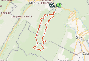

Length
17.1 km

Max alt
1681 m

Uphill gradient
865 m
Km-Effort
29 km

Min alt
1136 m

Downhill gradient
871 m
Boucle
Yes
Creation date :
2014-12-10 00:00:00.0
Updated on :
2014-12-10 00:00:00.0
7h14
Difficulty : Medium

FREE GPS app for hiking
 SityTrail
IGN / Geographical institutes
SityTrail Plus
The world is yours!
About
Trail Walking of 17.1 km to be discovered at Auvergne-Rhône-Alpes, Ain, Gex. This trail is proposed by ludo39.
Positioning
Country:
France
Region :
Auvergne-Rhône-Alpes
Department/Province :
Ain
Municipality :
Gex
Location:
Unknown
Start:(Dec)
Start:(UTM)
271208 ; 5138213 (32T) N.
Comments