


2012-02-04 16h39m58

ludo39
User
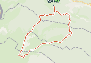

Length
11.9 km

Max alt
1671 m

Uphill gradient
677 m
Km-Effort
21 km

Min alt
1182 m

Downhill gradient
677 m
Boucle
Yes
Creation date :
2014-12-10 00:00:00.0
Updated on :
2014-12-10 00:00:00.0
5h05
Difficulty : Medium

FREE GPS app for hiking
 SityTrail
IGN / Geographical institutes
SityTrail Plus
The world is yours!
About
Trail Walking of 11.9 km to be discovered at Vaud, District de Nyon, Saint-Cergue. This trail is proposed by ludo39.
Positioning
Country:
Switzerland
Region :
Vaud
Department/Province :
District de Nyon
Municipality :
Saint-Cergue
Location:
Unknown
Start:(Dec)
Start:(UTM)
278927 ; 5147683 (32T) N.
Comments