Trail Cycle Sainte-Cécile-les-Vignes - Circuit Vélo - Circuit Aygues Ouvèze -  Ste Cecile les vignes - Photo

Circuit Vélo - Circuit Aygues Ouvèze - Ste Cecile les vignes

 tracegps
tracegps

User

© OpenStreetMap contributors
Length
Length
26 km
Max alt
Max alt
156 m
Uphill gradient
Uphill gradient
194 m
Km-Effort
Km-Effort  
28 km
Min alt
Min alt
66 m
Downhill gradient
Downhill gradient
195 m
Boucle
Boucle
Yes
Creation date :
2014-12-10 00:00:00.0
Updated on :
2014-12-10 00:00:00.0

(0 Reviews)

Cycle
Cycle
2h30
Difficulty : Medium

Scan this QR Code to open this trail in the SityTrail application

FREE GPS app for hiking

Logo SityTrail SityTrail

IGN / Geographical institutes

Download SityTrail from the App Store Download SityTrail from Google Play

Logo SityTrail SityTrail World

The world is yours!

Download SityTrail from the App Store Download SityTrail from Google Play Download SityTrail on Huawei AppGallery

About

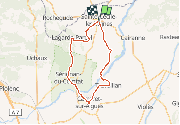
Trail Cycle of 26 km to be discovered at Provence-Alpes-Côte d'Azur, Vaucluse, Sainte-Cécile-les-Vignes. This trail is proposed by tracegps.

Description

Traversant une partie du Plan de Dieu et du massif d’Uchaux, ce circuit est le parcours familial par excellence*. Dans les villages et paysages traversés, les fontaines, lavoirs et ruisseaux y sont plus qu’ailleurs présents : vous franchirez par exemple à deux reprises l’Aygues. La viticulture laisse aussi une empreinte importante avec deux appellations Côtes du Rhône Villages : Massif d’Uchaux et Plan de Dieu. *Attention toutefois à la traversée de la départementale à la sortie de Sérignan du Comtat ; sur les routes à faible fréquentation la vigilance reste de mise. A noter aussi la montée vers Lagarde Paréol. Départ du parking à Sainte-Cécile-les-Vignes, « Jardin de la fontaine », à côté du boulodrome en face la route de Lagarde Paréol sur le tour de ville. Retrouvez plus d’informations et téléchargez la fiche du circuit sur le site de la Provence en vélo.

Elevation profile

Photos

Positioning

Country:
France
Region :
Provence-Alpes-Côte d'Azur
Department/Province :
Vaucluse
Municipality :
Sainte-Cécile-les-Vignes
Location:
Unknown
Start:(UTM)
650702 ; 4900873 (31T) N.

Trails nearby

Trail Walking Cairanne - Cairanne - Photo
Walking
legios84

Walking

Medium
(1)
Cairanne, Provence-Alpes-Côte d'Azur, Vaucluse, France
22 km | 28 km-effort
4h 32min
Yes
Trail Walking Rochegude - rocherude - Photo
Walking
gout.marc

Walking

Very easy
(1)
Rochegude, Auvergne-Rhône-Alpes, Drôme, France
12.3 km | 16.4 km-effort
2h 30min
Yes
Trail Walking Cairanne - 170919 EnCours - Photo
Walking
MarcheEtReve

Walking

Very easy
Cairanne, Provence-Alpes-Côte d'Azur, Vaucluse, France
7.9 km | 11 km-effort
2h 19min
Yes
Trail Walking Cairanne - cairanne sentier bouteille - Photo
Walking
Vero7684

Walking

Easy
Cairanne, Provence-Alpes-Côte d'Azur, Vaucluse, France
5.8 km | 8 km-effort
1h 38min
No
Trail Walking Cairanne - Les Terrasses de l'Aygues - Photo
Walking
MarcLEBARON

Walking

Easy
Cairanne, Provence-Alpes-Côte d'Azur, Vaucluse, France
11.5 km | 15.3 km-effort
3h 4min
Yes
Trail Walking Cairanne - Cairanne  - Photo
Walking
aitkhedache

Walking

Very easy
Cairanne, Provence-Alpes-Côte d'Azur, Vaucluse, France
4.9 km | 7 km-effort
2h 10min
No
Trail Walking Rochegude - Rochegude - Photo
Walking
Cricounet84

Walking

Medium
Rochegude, Auvergne-Rhône-Alpes, Drôme, France
13.1 km | 17 km-effort
4h 35min
Yes
Trail Walking Cairanne - cairanne par les falaises - Photo
Walking
Vero7684

Walking

Very easy
Cairanne, Provence-Alpes-Côte d'Azur, Vaucluse, France
11 km | 14.5 km-effort
2h 51min
Yes
Trail Walking Cairanne - Croix du Serre de la Garde - Photo
Walking
counoise

Walking

Easy
Cairanne, Provence-Alpes-Côte d'Azur, Vaucluse, France
13.9 km | 18.9 km-effort
3h 43min
Yes


Close
My subscriptions