


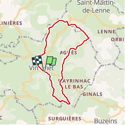
Les crêtes de Vimenet

tracegps
User


4h00
Difficulty : Medium

FREE GPS app for hiking
 SityTrail
IGN / Geographical institutes
SityTrail Plus
The world is yours!
About
Trail Walking of 13.7 km to be discovered at Occitania, Aveyron, Vimenet. This trail is proposed by tracegps.
Description
Randonnée agréable, que du bon chemin et quasiment pas de goudron, l'aller retour vers la chapelle vaut la peine, petite chapelle entièrement restaurée au fond du bois 1 km aller-retour. Vous aurez peut-être la chance comme nous de rencontrer une biche ou un chevreuil. Le centre du village de Vimenet est clos, église parfaitement restaurée. Bonne balade.
Photos


Positioning
Comments
VIMENET Super balade , le choix avec 2 restaurants les Bergers et chez Josy super bon tout les deux , très belle randonnée , très beau village ,très belle église à voir . Joël et lucie