


2012-04-06 - 19h36m16

Valery01
User
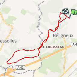

Length
8.7 km

Max alt
268 m

Uphill gradient
186 m
Km-Effort
11.2 km

Min alt
208 m

Downhill gradient
186 m
Boucle
Yes
Creation date :
2014-12-10 00:00:00.0
Updated on :
2014-12-10 00:00:00.0
51m
Difficulty : Easy

FREE GPS app for hiking
 SityTrail
IGN / Geographical institutes
SityTrail Plus
The world is yours!
About
Trail Running of 8.7 km to be discovered at Auvergne-Rhône-Alpes, Ain, Béligneux. This trail is proposed by Valery01.
Positioning
Country:
France
Region :
Auvergne-Rhône-Alpes
Department/Province :
Ain
Municipality :
Béligneux
Location:
Unknown
Start:(Dec)
Start:(UTM)
665449 ; 5082284 (31T) N.
Comments