2012-04-26 13h50m28

norbertmarteau
User
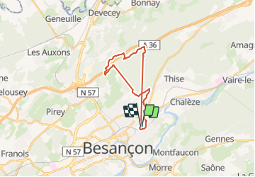

Length
21 km

Max alt
415 m

Uphill gradient
378 m
Km-Effort
26 km

Min alt
269 m

Downhill gradient
376 m
Boucle
Yes
Creation date :
2014-12-10 00:00:00.0
Updated on :
2014-12-10 00:00:00.0
1h54
Difficulty : Unknown

FREE GPS app for hiking
 SityTrail
IGN / Geographical institutes
SityTrail Plus
The world is yours!
About
Trail Other activity of 21 km to be discovered at Bourgogne-Franche-Comté, Doubs, Besançon. This trail is proposed by norbertmarteau.
Positioning
Country:
France
Region :
Bourgogne-Franche-Comté
Department/Province :
Doubs
Municipality :
Besançon
Location:
Unknown
Start:(Dec)
Start:(UTM)
276608 ; 5237375 (32T) N.
Comments