Voie des vignes

phillux
User
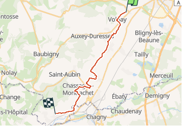

Length
18.2 km

Max alt
290 m

Uphill gradient
187 m
Km-Effort
21 km

Min alt
211 m

Downhill gradient
209 m
Boucle
No
Creation date :
2014-12-10 00:00:00.0
Updated on :
2014-12-10 00:00:00.0
--
Difficulty : Unknown

FREE GPS app for hiking
 SityTrail
IGN / Geographical institutes
SityTrail Plus
The world is yours!
About
Trail Cycle of 18.2 km to be discovered at Bourgogne-Franche-Comté, Côte-d'Or, Pommard. This trail is proposed by phillux.
Positioning
Country:
France
Region :
Bourgogne-Franche-Comté
Department/Province :
Côte-d'Or
Municipality :
Pommard
Location:
Unknown
Start:(Dec)
Start:(UTM)
636322 ; 5207646 (31T) N.
Comments