


Tour de la Roize Voreppe 2012-04-29 15h23m42

psesjs
User
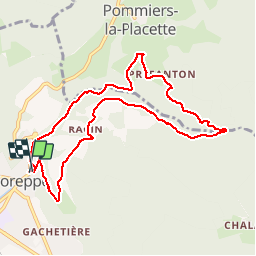

Length
10.2 km

Max alt
669 m

Uphill gradient
426 m
Km-Effort
15.9 km

Min alt
263 m

Downhill gradient
421 m
Boucle
Yes
Creation date :
2014-12-10 00:00:00.0
Updated on :
2014-12-10 00:00:00.0
4h37
Difficulty : Easy

FREE GPS app for hiking
 SityTrail
IGN / Geographical institutes
SityTrail Plus
The world is yours!
About
Trail Walking of 10.2 km to be discovered at Auvergne-Rhône-Alpes, Isère, Voreppe. This trail is proposed by psesjs.
Positioning
Country:
France
Region :
Auvergne-Rhône-Alpes
Department/Province :
Isère
Municipality :
Voreppe
Location:
Unknown
Start:(Dec)
Start:(UTM)
706825 ; 5019561 (31T) N.
Comments