


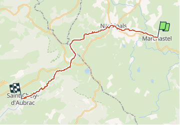
Compostelle 06 - Marchastel -> St-Chély-d'Aubrac

uru2010
User

Length
23 km

Max alt
1369 m

Uphill gradient
397 m
Km-Effort
29 km

Min alt
809 m

Downhill gradient
786 m
Boucle
No
Creation date :
2018-06-12 00:00:00.0
Updated on :
2018-06-12 00:00:00.0
9h04
Difficulty : Medium

FREE GPS app for hiking
 SityTrail
IGN / Geographical institutes
SityTrail Plus
The world is yours!
About
Trail Walking of 23 km to be discovered at Occitania, Lozère, Marchastel. This trail is proposed by uru2010.
Description
Chemin de St Jacques de Compostelle
Marchastel -> St-Chély-d'Aubrac
Positioning
Country:
France
Region :
Occitania
Department/Province :
Lozère
Municipality :
Marchastel
Location:
Unknown
Start:(Dec)
Start:(UTM)
508459 ; 4944170 (31T) N.
Comments