


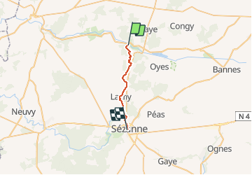
2012-04-25 Talus-Saint-Prix > Sézanne

mousetik
User

Length
16.2 km

Max alt
224 m

Uphill gradient
207 m
Km-Effort
19 km

Min alt
128 m

Downhill gradient
224 m
Boucle
No
Creation date :
2014-12-10 00:00:00.0
Updated on :
2014-12-10 00:00:00.0
4h20
Difficulty : Easy

FREE GPS app for hiking
 SityTrail
IGN / Geographical institutes
SityTrail Plus
The world is yours!
About
Trail Walking of 16.2 km to be discovered at Grand Est, Marne, Talus-Saint-Prix. This trail is proposed by mousetik.
Positioning
Country:
France
Region :
Grand Est
Department/Province :
Marne
Municipality :
Talus-Saint-Prix
Location:
Unknown
Start:(Dec)
Start:(UTM)
553128 ; 5409231 (31U) N.
Comments