


Montahut-Bourdils

yt34
User
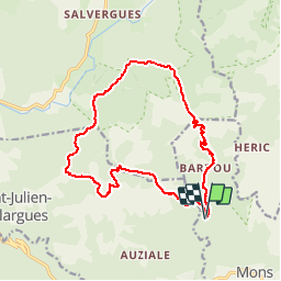

Length
17.1 km

Max alt
1074 m

Uphill gradient
749 m
Km-Effort
27 km

Min alt
443 m

Downhill gradient
740 m
Boucle
Yes
Creation date :
2014-12-10 00:00:00.0
Updated on :
2014-12-10 00:00:00.0
6h06
Difficulty : Medium

FREE GPS app for hiking
 SityTrail
IGN / Geographical institutes
SityTrail Plus
The world is yours!
About
Trail Walking of 17.1 km to be discovered at Occitania, Hérault, Mons. This trail is proposed by yt34.
Description
départ parking de l'airette


Positioning
Country:
France
Region :
Occitania
Department/Province :
Hérault
Municipality :
Mons
Location:
Unknown
Start:(Dec)
Start:(UTM)
495233 ; 4825618 (31T) N.
Comments