


Les étangs de Bouligneux

florent43
User
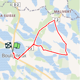

Length
7.2 km

Max alt
293 m

Uphill gradient
44 m
Km-Effort
7.8 km

Min alt
278 m

Downhill gradient
42 m
Boucle
Yes
Creation date :
2014-12-10 00:00:00.0
Updated on :
2014-12-10 00:00:00.0
4h00
Difficulty : Easy

FREE GPS app for hiking
 SityTrail
IGN / Geographical institutes
SityTrail Plus
The world is yours!
About
Trail Walking of 7.2 km to be discovered at Auvergne-Rhône-Alpes, Ain, Bouligneux. This trail is proposed by florent43.
Description
DDombes, le pays au mille étang
Positioning
Country:
France
Region :
Auvergne-Rhône-Alpes
Department/Province :
Ain
Municipality :
Bouligneux
Location:
Unknown
Start:(Dec)
Start:(UTM)
654061 ; 5098621 (31T) N.
Comments
Uniquement sur route !...
Uniquement sur route !...
bon petit tour