Trail Walking Bouligneux - Les étangs de Bouligneux - Photo

Les étangs de Bouligneux

© OpenStreetMap contributors
Length
Length
7.2 km
Max alt
Max alt
293 m
Uphill gradient
Uphill gradient
44 m
Km-Effort
Km-Effort  
7.8 km
Min alt
Min alt
278 m
Downhill gradient
Downhill gradient
42 m
Boucle
Boucle
Yes
Creation date :
2014-12-10 00:00:00.0
Updated on :
2014-12-10 00:00:00.0

(3 Reviews)

Walking
Walking
4h00
Difficulty : Easy

Scan this QR Code to open this trail in the SityTrail application

FREE GPS app for hiking

Logo SityTrail SityTrail

IGN / Geographical institutes

Download SityTrail from the App Store Download SityTrail from Google Play

Logo SityTrail SityTrail World

The world is yours!

Download SityTrail from the App Store Download SityTrail from Google Play Download SityTrail on Huawei AppGallery

About

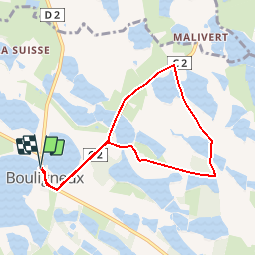
Trail Walking of 7.2 km to be discovered at Auvergne-Rhône-Alpes, Ain, Bouligneux. This trail is proposed by florent43.

Description

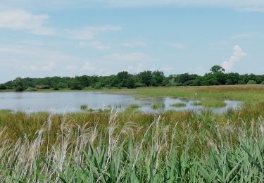
DDombes, le pays au mille étang

Elevation profile

Positioning

Country:
France
Region :
Auvergne-Rhône-Alpes
Department/Province :
Ain
Municipality :
Bouligneux
Location:
Unknown
Start:(UTM)
654061 ; 5098621 (31T) N.

Comments

Please log in to post a review or rate the element


Uniquement sur route !...


Uniquement sur route !...


bon petit tour


Trails nearby

Trail Mountain bike Villars-les-Dombes - 01 vtt Dombes circuit 19  43km 380m 05 2020 - Photo
Mountain bike
SyMA

Mountain bike

Easy
Villars-les-Dombes, Auvergne-Rhône-Alpes, Ain, France
44 km | 49 km-effort
3h 19min
Yes
Trail Motor Villars-les-Dombes - Sortie Solex Villars HZD - Photo
Motor
BGO

Motor

Very easy
Villars-les-Dombes, Auvergne-Rhône-Alpes, Ain, France
59 km | 65 km-effort
Unknown
Yes
Trail Walking Sainte-Olive - 01 - SAINTE-OLIVE - Photo
Walking
AndreLACOMBE

Walking

Very easy
Sainte-Olive, Auvergne-Rhône-Alpes, Ain, France
6.6 km | 7.1 km-effort
2h 29min
Yes
Trail Walking Bouligneux - Bouligneux-Etang de la petite Bozonnière-Ain - Photo
Walking
ThierryJ01

Walking

Medium
Bouligneux, Auvergne-Rhône-Alpes, Ain, France
7 km | 7.6 km-effort
1h 43min
Yes
Trail Walking Sainte-Olive - Sainte Olive-Etang de Chardonnet-Ain - Photo
Walking
ThierryJ01

Walking

Medium
Sainte-Olive, Auvergne-Rhône-Alpes, Ain, France
6.5 km | 7 km-effort
1h 35min
Yes
Trail Cycle Villars-les-Dombes - ain en velo circuit 19 - Photo
Cycle
Baroux

Cycle

Very easy
Villars-les-Dombes, Auvergne-Rhône-Alpes, Ain, France
43 km | 48 km-effort
2h 46min
Yes
Trail Cycle Villars-les-Dombes - ain en velo circuit 19 - Photo
Cycle
Baroux

Cycle

Very easy
Villars-les-Dombes, Auvergne-Rhône-Alpes, Ain, France
43 km | 48 km-effort
Unknown
Yes
Trail Motor Villars-les-Dombes - Sortie Solex Villars HDZ 2 - Photo
Motor
BGO

Motor

Very easy
Villars-les-Dombes, Auvergne-Rhône-Alpes, Ain, France
61 km | 67 km-effort
Unknown
Yes
Trail Cycle Villars-les-Dombes - De Villars à Chatillon en vélo - Photo
Cycle
jmdumas

Cycle

Easy
Villars-les-Dombes, Auvergne-Rhône-Alpes, Ain, France
35 km | 39 km-effort
Unknown
Yes


Close
My subscriptions