


Autour des Roches et de Chapteuil

florent43
User
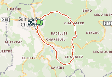

Length
6.9 km

Max alt
962 m

Uphill gradient
179 m
Km-Effort
9.3 km

Min alt
822 m

Downhill gradient
179 m
Boucle
Yes
Creation date :
2014-12-10 00:00:00.0
Updated on :
2014-12-10 00:00:00.0
--
Difficulty : Easy

FREE GPS app for hiking
 SityTrail
IGN / Geographical institutes
SityTrail Plus
The world is yours!
About
Trail Walking of 6.9 km to be discovered at Auvergne-Rhône-Alpes, Haute-Loire, Saint-Julien-Chapteuil. This trail is proposed by florent43.
Positioning
Country:
France
Region :
Auvergne-Rhône-Alpes
Department/Province :
Haute-Loire
Municipality :
Saint-Julien-Chapteuil
Location:
Unknown
Start:(Dec)
Start:(UTM)
583672 ; 4987163 (31T) N.
Comments
sympa belle vue