


45km rando Octocote

Valery01
User
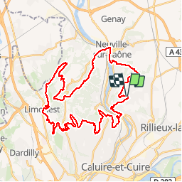

Length
46 km

Max alt
561 m

Uphill gradient
1346 m
Km-Effort
64 km

Min alt
165 m

Downhill gradient
1348 m
Boucle
Yes
Creation date :
2014-12-10 00:00:00.0
Updated on :
2014-12-10 00:00:00.0
3h37
Difficulty : Difficult

FREE GPS app for hiking
 SityTrail
IGN / Geographical institutes
SityTrail Plus
The world is yours!
About
Trail Mountain bike of 46 km to be discovered at Auvergne-Rhône-Alpes, Métropole de Lyon, Fontaines-Saint-Martin. This trail is proposed by Valery01.
Positioning
Country:
France
Region :
Auvergne-Rhône-Alpes
Department/Province :
Métropole de Lyon
Municipality :
Fontaines-Saint-Martin
Location:
Unknown
Start:(Dec)
Start:(UTM)
643986 ; 5078466 (31T) N.
Comments