


Roque rouge

yt34
User
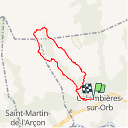

Length
6.9 km

Max alt
1032 m

Uphill gradient
790 m
Km-Effort
17.5 km

Min alt
243 m

Downhill gradient
791 m
Boucle
Yes
Creation date :
2014-12-10 00:00:00.0
Updated on :
2014-12-10 00:00:00.0
--
Difficulty : Medium

FREE GPS app for hiking
 SityTrail
IGN / Geographical institutes
SityTrail Plus
The world is yours!
About
Trail Walking of 6.9 km to be discovered at Occitania, Hérault, Colombières-sur-Orb. This trail is proposed by yt34.
Description
départ colombières esquino d'ase puis roque rouge
Positioning
Country:
France
Region :
Occitania
Department/Province :
Hérault
Municipality :
Colombières-sur-Orb
Location:
Unknown
Start:(Dec)
Start:(UTM)
500463 ; 4825171 (31T) N.
Comments